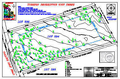
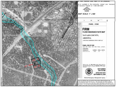
Landmark Technologies

Danial L Puckett

Cell: (928) 205-2800
PO Box 1156
1539 Falcon Lane
Pinedale, Arizona 85934

Email: landmarksurvey411@gmail.com
Website: landmarksurvey.info

HOME
RECORDS
SERVICES
POLICIES

Services

Boundary Survey

1) Reasearch property to be surveyed
2) Locate and flag boundary corners.
3) Set permanent stamped aluminum cap or stamped aluminum washer on all on accepeted property corners.
4) Check boundary lines for encroachments.
5) Check for deed gaps and overlaps.
6) Provide additional survey data upon request (locate buildings, utilities, etc).
7) Provide 1 Mylar copy to County Recorders Office.
8) Provide 2 Paper copies to customer.
9) Provide Autocad file and PDF file through Landmark web page.

ALTA Surveys

1) Provide boundary survey according to ALTA Specifications which includes 1-9 of standard boundary survey.
2) Provide copy of ALTA Specifications to customer.
3) In order to meet ALTA specitications the customer will be required to:
a) Provide current title report.
b) Complete Table A - Optional Survey Responsibilities and Specifications.

Note: Our "boundary survey" exceeds most ALTA requirements - An ALTA survey is likely to be more than you need unless it is required by bank or mortgage company. ALTA are more expensive because the extra time required to locate detail not related to the boundary as well as extra time required to process the paperwork.

Lot Splits and Consolidations

Note: Requires Boundary Survey and is done in accordance with the requirement of the county in which the work is performed.

Apache County

1) Check Zoning to see if parcel can be split
2) Provide County with:
        a) County Application Form - Requires original owners signature
        b) Legal for each lot with Surveyors Seal
        c) Mylar to P&Z
        d) Survey recording fee - made out to Apache Co. Recorders
        e) Split Fee - varies with the number of lots - made out to P&Z
        f) Limit split to 5 parcel per owner before subdivision laws apply
        g) Local city requirements/restrictions may also apply

Navajo County Splits

        a) Check Zoning to see if parcel can be split
        b) Mylar to Recorders office
        c) Copy of legals for each lot with Surveyors Seal
        d) Limit split to 5 parcels per owner before subdivision laws apply
        e) A deed must be recorded by owner to legally split the property
        f) Local city requirements/restrictions may also apply

Topography Surveys

Topo

1) Locate one foot contour lines with five foot index contour lines
2) Provide Tins, Grids, Triangulated Grids, Dems, and point files upon request
3) Large area aerial control and aerial topographies by request
4) Locate significant land features.
        a) Rock outcroppings
        b) Trees with a customer-specified minimum diameter
        c) Washes and drainage ditches
        d) Buildings and structures
        e) Utilities by request

Other Services

Fema Pic

Elevation Certification- Elevation Certificates are completed according to the latest FEMA National Flood Insurance Program forms and standards. When applicable, State Standard 2-96 will be used to calculate the Base Flood Elevations when no Base Flood Elevation has been determined.

House Staking - House or building staking can be done for customers who wish to see the location of their house before construction starts. It is an economical and quick way to lay out foundations prior to pouring concrete or block work. House staking can also eliminate future setback problems. Once a staking job is set up, the house location can be moved or rotated easily in the field with the customer present, and then used to regenerate a plot plan for the customer.

Construction Staking - Construction staking is much more involved than house staking. If you need a company with years of experience in all aspects of staking, whether it's a condominium, restaurant, school, parking lot,sewer lines, or just a simple detention pond, Landmark can help you get the job done right.

Other Survey Services - Information on request.